Tropical Storm Bertha targets Gulf Coast with heavy rain
Bertha formed south of the Florida Panhandle with 40 mph winds, and forecasters warned of flooding rain and storm surge along the Gulf Coast.
By Georgia Hale · Staff Writer
3 min read
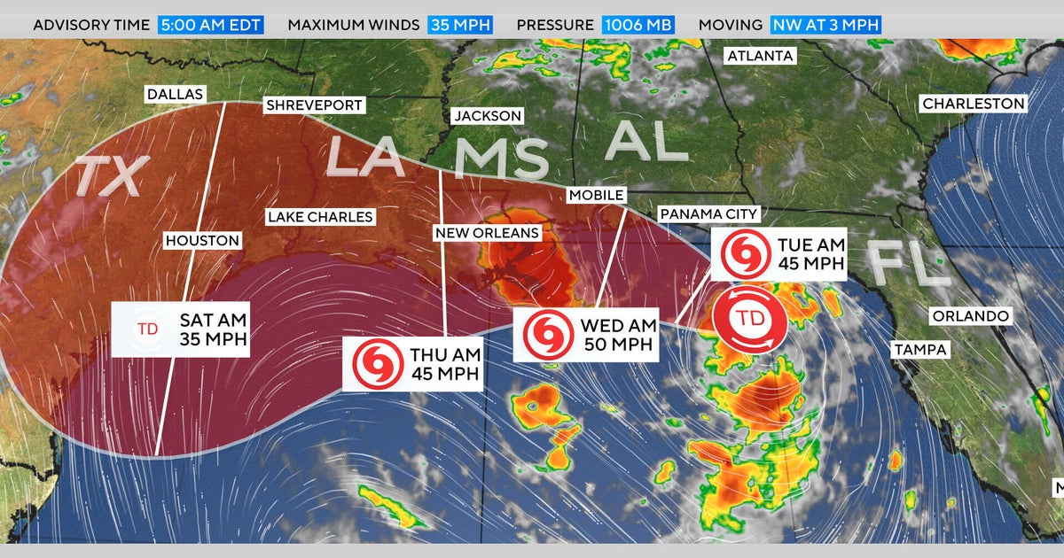
Tropical Storm Bertha formed Monday in the Gulf, putting a long stretch of the Gulf Coast on alert for days of rain, flooding risks and rising water.
The National Weather Service said the storm was south of the Florida Panhandle on Monday with maximum sustained winds of 40 mph. Bertha was creeping west-northwest at about 3 mph, giving coastal communities time to watch, prepare and brace for a soggy week.
Bertha is the second named storm of the 2026 Atlantic hurricane season, following Tropical Storm Arthur, which made landfall in June along the Texas Gulf Coast.
Where Bertha is headed
A CBS News forecast map showed the system, formerly Tropical Depression Two, tracking along the Gulf Coast. The projected path takes it west from the Florida Panhandle toward the New Orleans area, then on toward eastern Texas later this week.
The National Weather Service said Monday that the system was expected to move slowly northwest through the night, then turn west-northwest or west.
“On the forecast track, the depression will move near or along the northern Gulf coast during the next several days,” the weather service said Monday.
The slow pace is a problem. A storm does not need extreme winds to cause trouble when it has time to dump rain over the same areas for days.
Watches stretch from Florida to Louisiana
A Tropical Storm Watch was in effect from the Ochlockonee River in Florida to the Jefferson and Plaquemines Parish border in Louisiana, according to the National Weather Service.
A Storm Surge Watch was also in effect from the Alabama and Florida border to the mouth of the Mississippi River.
Forecasters said Bertha could bring rainfall totals up to 8 inches in some places. Rain was expected through the week along the Gulf Coast and nearby inland areas from western Florida to the Texas coast.
Parts of Alabama, Mississippi and Louisiana were also expected to feel the effects, with the weather service warning that the rain could trigger flash flooding.
The system could also push water onto the coast. Forecasters warned storm surge could lift water levels as much as 4 feet in some spots along the Gulf Coast.
Second named storm of the season
Bertha arrived just weeks after Arthur became the first named storm of the 2026 Atlantic hurricane season. Arthur made landfall in June along the Gulf Coast of Texas.
The Atlantic season was already active enough by Monday to have its second named system, and Bertha’s expected track keeps several states in the rain zone for days.
For residents from Florida to Texas, the main threats listed by forecasters were not limited to wind. Heavy rain, flash flooding and storm surge were the hazards to watch as Bertha drifted near or along the northern Gulf Coast.
This story draws on original reporting from CBS News.